I've FINALLY started a blog on travel (and maybe the food that comes with it)! Now, what took me so long? I could give myself reasons like "no time", "not my thing" or "no one cares," then I realize I've been making excuses all the while. Travel and food are two of my simple yet major joys in life. If food is what feeds my body, travel is what feeds my soul. Yes, they come with a price and they are not those that you can see, touch or wear everyday. Others say going on trips and dining out is just a waste of money. I say they're more than what I spend for. You'll find out why as you go along my succeeding posts.
 |
| Map of Cebu Province |
It's always a good idea to start local when travelling. You don't only have the advantage of speaking the local language (which would prove very useful when trying to bargain for things to pay for or buy), you pretty much know where the ports and bus terminals to wherever you have to go. In other words, no one knows your place better than you do. I guess I would consider myself lucky to be a resident of Cebu. There are so many places I'm able to go and explore just within the island-city I call home. The best part is that I'm able to fully enjoy the beauty and ambiance of nature, but don't end up spending so much. As to my upcoming trips, I will post a personally-prepared itinerary of my chosen destination, the followed by a post on the after-trip details. Thinking about it already excites me!
Below are several places within Cebu Province from north to south that I've had the pleasure of visiting. I'd like to list them down for me keep track of the places I've been and to share it with whoever comes across this post. Note that I only gave brief descriptions of each place and I'd be happy to provide travel tips on these places upon request. The list of places I've been beyond Cebu will be featured next.
Bantayan Island
 |
| Map of Bantayan Island by Google Maps |
 |
| Santa Fe, Bantayan |
 |
| Ogtong Cave, Bantayan |
Bantayan Island is located in Northern Cebu from Hagnaya Port in the town of San Remigio. This island easily became a popular summer destination because of its white sand beaches comparative to the island of Boracay in Aklan minus the commercial establishments. It boasts of its clear turquoise waters and natural pool inside Ogtong Cave. Other places to visit in the island is the nature park situated within a resort and the dried fish market where most of Cebu's supply of quality dried seafood products come from. The island is also known for its grand observance of the Holy Week during the lenten season where the main event on Maundy Thursday and Good Friday is a solemn foot procession depicting the passion and death of Christ Jesus in large floats bearing life-sized religious images, which draws in many tourists. It celebrates its annual fiesta every June 29 in honor of their religious patrons Saints Peter an Paul.
Malapascua Island
 |
| Map of Malapascua by Google Maps |
 |
| Sunrise View from the Edge of Bounty Beach, Malapascua |
 |
| Gato Island, one of Malapascua's dive sites |
Malapascua Island is located in Northern Cebu from Maya Port in the town of Daanbantayan. Aside from its white sand beach, it's best known as a diving destination for regular sightings of thresher sharks and manta rays. Its beautiful coral gardens also makes the island ideal for snorkeling. For other diving adventures, experienced divers can do wreck, cave and muck diving in dive sites near the island. It celebrates its annual fiesta every May 11 and 12 where a grand fluvial boat parade is held in honor of its religious patron Virgin Delos Desamparados.
Borbon
 |
| Map of Borbon by Google Maps |
 |
| Guiwanon Cold Spring, Tabogon Borbon |
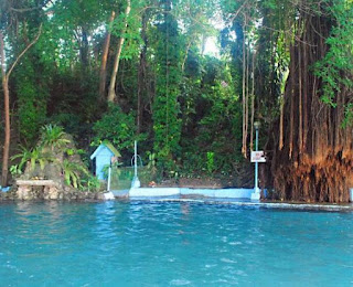
Borbon is located northeast of Cebu. This farming and fishing town is known for its eco-tourism site which is the Silmugi River where visitors can go on short river cruises. Another attaction is the Guiwanon Cold Spring, which has an acacia tree that serves as a canopy providing natural shade while swimming in the pool of fresh and salt water. It celebrates its annual fiesta every third Sunday of January (same time as Sinulog Festival) in honor of its religious patron St. Sebastian The Martyr.
Tuburan
 |
| Map of Tuburan by Google Maps |
 |
| Molobolo Cold Spring, Tuburan |
Tuburan is located northwest of Cebu. The town derived its name from the local term tubod (meaning spring) because of the abundance of natural springs which is the main source of water of the locals. It is known for the Molobolo Cold Spring which is a lot bigger and more developed than Guiwanon Cold Spring in Tabogon, Borbon. It celebrates its annual fiesta every June 13 in honor of its religious patron San Antonio de Padua.
Cebu City
 |
| Barangay Tabunan, Cebu City |
 |
| Flower Farm at Sitio Cantipla, Brgy. Tabunan, Cebu City |
Tabunan is one of the many mountain barangays within Cebu City (before reaching the town of Balamban) which is accessible via Trans-central Highway coming from Barangay Lahug and known mainly for its flower farms, although there are also vegetable farms but not as large-scale as those in Mantalongon, Dalaguete. This is the perfect place for those needing a cool retreat from the hustle and bustle of city life or to escape the scorching heat of summer. Adventure-seekers who are willing to spend a bit more can opt for trail-riding on horseback, passing through creeks and a lake and maybe go beach-riding or horse-surfing. There is no major annual barangay fiesta to speak of as of yet, but the Cebu City government is planning to stage a Mountain and Flower Festival in October this year (2015) for its mountain barangays which includes Tabunan and others namely Bonbon, Babag, Busay, Buol, Sinsin, Sudlon 1, Sudlon 2 and Sibugay.
Mactan Island
Mactan Island is connected to Cebu mainland on its eastern side by two bridges namely the Mandaue-Mactan Bridge or more commonly called "old bridge" and the Marcelo Fernan Bridge or "new bridge" so it's very convenient for land travel, especially when going on spur-of-the-moment beach trips. Since it is where the airport for domestic and international flights coming in and out of Cebu is situated, travellers can easily hit the beach not too long after arrival. Aside from its several luxury resort hotels for rest and recreation, this coral island offers activities like diving, snorkeling, jet skiing, sailing and island-hopping to nearby islets such as Hilutungan-Fish Sanctuary, Pandanon, Nalusuan-Marine Sanctuary, Caohagan-Marine Sanctuary and Olango-Bird Santuary and other smaller ones like Tingo, Sulpa and Talima. It celebrates its annual fiesta every November 21 where a fluvial boat parade is held in honor of its religious patron Birhen sa Regla (Our Lady of the Rule) and the anniversary every April 27 of the Kadaugan sa Mactan (Victory at the Battle of Mactan) where it starts a week in advance with a street-dancing festival.
Moalboal
 |
| Map of Moalboal by Google Maps |
 |
| Edge of Basdako, Moalboal |
Moalboal is located in the southwestern tip of Cebu, extending as a peninsula. It is known for recreational diving because of its rich marine life. It's most popular dive spot is Pescador Island about three (3) kilometers away from the mainland. It is also known for its two major white sand beaches namely White Beach or Basdako (literally big sand) and Panagsama Beach or Basdiot (literally small sand) where most of the resorts and dive shops are found. It celebrates its annual fiesta every May 15 and 16 in honor of their religious patron San Juan Nepomuceno.
Badian
 |
| Map of Badian by Google Maps |
 |
| Kawasan Falls, Badian |
Badian is located southwest of Cebu, a town next to Moalboal when going southward. It is best known for Kawasan Falls which is about 20 minutes by foot from the highway, although there are single-type motorcycles or habal-habal waiting at the entrance for those too tired to walk all the way to the waterfalls. A few years ago, the falls was closed for an entire year for rehabilitation and now it's nice to see the place regain its vibrance and the improvements within its perimeter like cottages and room accommodations. Visitors can go swimming in the cool turquoise pool of water, go rafting under the falls for a good water massage or if feeling adventurous, canyoneering on all three levels of the falls. The town also has known beaches found in Zaragoza Island not far off the coast from the mainland or just within the mainland called Lambug Beach which is open to the public. It celebrates its annual fiesta every July 24 and 25 in honor of its religious patron St. James the Apostle.
Dalaguete
 |
| Map of Dalaguete by Google Maps |
 |
| Osmeña Peak, Dalaguete |
 |
| Cabbage Farm in Mantalongon, Dalaguete |
Dalaguete is located south of Cebu in the mountainous part of the province which has a cooler climate suitable for planting vegetables like cabbage, pechay, carrots, sayote, green onion, eggplant, tomato and native pepper among others. Because of its vast vegetable plantations, it became popularly known as the Vegetable Basket of Cebu. The vegetables are mainly grown in the barrio of Mantalongon and are delivered on foot by farmers carrying huge baskets of produce on their heads. Another attraction of the town is Osmeña Peak, the highest point in the province, that gives a captivating view of the bay and Zaragoza Island of the town of Badian. For added adventure, hikers can traverse from the peak and pass through pure wilderness until reaching magnificent Kawasan Falls in Badian. It celebrates its annual fiesta every February 9 and 10 in honor of their religious patron San Guillermo.
Oslob
 |
| Map of Oslob by Google Maps |
 |
| Gigantic Whaleshark, Oslob |
 |
| Sumilon Island, Oslob |
 |
| Tumalog Falls, Oslob |
Oslob is located south of Cebu and is the second to the last town southward. The town became popular because of the butanding or whalesharks found on its seas not very far from its coastline. Before jumping on a small boat to watch or actually swim with the whalesharks, a mandatory orientation must be attended by visitors to be aware of the guidelines for the protection of the "gentle sea giants." Each group of visitors, aided by boatmen for a fee, will be given 30 minutes to spend with the whalesharks. Those who wish to stay longer may cross to Sumilon Island and swim or sunbathe by the sandbar, or stay in the mainland and visit Tumalog Falls accessible by a 10-minute habal-habal ride. It celebrates its annual fiesta every December 8 in honor of their religious patron Our Lady of the Immaculate Conception.
Santander
 |
| Map of Santander by Google Maps |
 |
| Private Beach with a View of Sumilon Island, Santander |
Santander is located in the southernmost tip of Cebu and has access to Dumaguete City in Negros through its Liloan Port. Negros can even be seen clearly from the port as it is only about 30 minutes away by ferry. The town is also known for diving because black-tip reef shark sightings. It celebrates its annual fiesta every third Sunday of April in honor of their religious patron St. Gabriel the Archangel.
These places are not even half of what the province has in store for tourists and locals to explore. I intend to add more to my list of places worth visiting in Cebu and make a detailed D.I.Y. travel post for each. Stay tuned for more posts as my journey as a budget traveler is far from over.


No comments:
Post a Comment